


So you want to climb Mt. Shasta? I don’t blame you! Climbing Mount Shasta was on my list of goals since I first discovered a love for mountaineering and set a big goal to one day eventually climb all of the California Fourteeners.
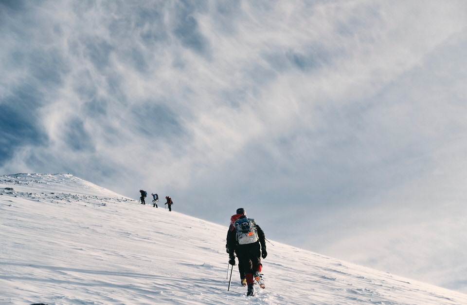
Unlike some of the other California 14ers, like Mount Whitney and Mount Langley, Mount Shasta is more complicated to plan and requires you to have some technical mountaineering skills.
(So if you’re still new to this whole mountaineering thing, then I highly recommend you check out our guide on how to get into mountaineering!)
This Mount Shasta climbing guide goes into depth on the logistics of planning your climb up Mount Shasta’s Avalanche Gulch route – plus what to do if you are a beginner and need to learn mountaineering skills.
Mount Shasta’s Avalanche Gulch route is a great beginner route to learn mountaineering, but this learning is best done with a guide (more details on that later in the post). Even though this route is “beginner,” be aware that it is still a very physically challenging route!
And if you’re a visual kind of person, I loved this video from Tava on YouTube. It’s a great short climb showing the Avalanche Gulch route and what your Mount Shasta climb will look like. Check it out below!
Still stoked on planning your Mount Shasta Climb via Avalanche Gulch? Then read on, my friend!
WHAT WE WILL COVER IN THIS CLIMBING MT. SHASTA GUIDE
As I mentioned above, if you are skilled in mountaineering, climbing Mount Shasta via Avalanche Gulch is a great route to add to your mountaineering peak-bagging list.
However, if you are new to mountaineering, be sure to seek out a professional guide. You should learn the proper skills for mountaineering from a trained guide or experienced mentor before ever attempting one on your own.
There are many routes up Mount Shasta, and if you want to learn more, check out The Mt. Shasta Book which contains a list of all of the different routes up the mountain. This blog post will only really go into depth on climbing Mount Shasta via Avalanche Gulch Route.
Here’s what we’re going to cover in this climbing Mount Shasta post:
Climbing Mt. Shasta Trail Stats - All the nitty-gritty details for the Avalanche Gulch Route in one spot, including mileage, elevation gain, & more.
How to Get a Mt. Shasta Climbing Permit - Required for climbing to the summit!
Best Time to Climb Mount Shasta – Details about the best time to climb Mt. Shasta and typical Mt. Shasta summit weather to expect on your trip.
Mt. Shasta Avalanche Gulch Trail Map & GPX Files - I've created a map detailing the whole trail that you can explore, including a look at the elevation gain/profile of the hike. You can also download this file as a GPX file to upload into your own personal GPS device.
How to Get to the Avalanche Gulch Trailhead – Driving and parking recommendations.
Mt. Shasta Camping – Where to camp on and off the trail when visiting.
Itinerary for Climbing Mount Shasta - I’ll walk you through my experience and suggested itinerary for climbing Mt. Shasta via the Avalanche Gulch Route.
Important Mount Shasta Climbing Safety Tips – The top hazards to expect along the trail.
Climbing Mount Shasta Gear List – An essential packing list for the climb. Don’t hit the trail without these things!
Mt. Shasta Avalanche Gulch Trip Report – My personal account on the Avalanche Gulch route.
If you’re looking for something specific, feel free to skip ahead to the section you’re looking for!
Plus, be sure to check out the bottom of this post to find more California trail guides and other additional hiking, camping, and backpacking resources!
GRAB MY [FREE] OUTDOOR BACKPACKER STARTER KIT:
I created the Ultimate Outdoor Backpacker Starter Kit for you (and it's FREE)! This starter kit is filled with 14 pages of my best hiking and backpacking tips to help you learn what it takes to become a safe, confident, and self-sufficient outdoor backpacker!
1. CLIMBING MT. SHASTA TRAIL STATS
If you’re anything like me, the first thing you want to know about a trail is the stats and basic info so I can quickly figure out what the hike is all about. So here you go!
MOUNT SHASTA AVALANCHe GULCH ROUTE QUICK FACTS
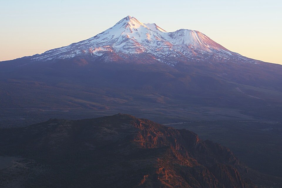
Mt. Shasta Summit Elevation: 14,179 feet
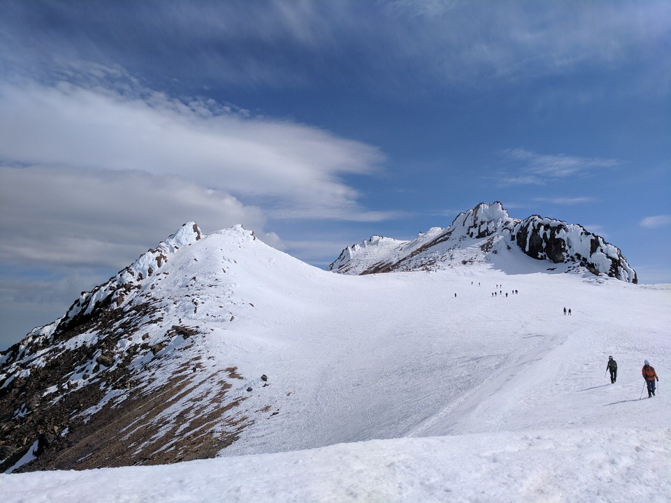
Trail to Summit: There are many routes up Mount Shasta. In this post, we will discuss the Avalanche Gulch Route. Avalanche Gulch is the second technically easiest route up Mount Shasta and by far the most popular.
Type of Trail: Out and Back
Avalanche Gulch Route Mileage: 11 miles (that’s right... 5.5 miles with 7,300' gain!) Check out Section 4, “Mt. Shasta Avalanche Gulch Trail Map & GPX Files” for more details.)
Total Elevation Gain: ~7,300 feet total elevation gain
Mount Shasta Avalanche Gulch Trailhead: Bunny Flat Trailhead
Trailhead Elevation: 6,950 feet
How long does it take to climb Mt Shasta? The Avalanche Gulch route can be climbed in anywhere from 1 to 3 days. The time required really will depend on your physical fitness and your mountaineering skills. Guided trips usually range from 2-4 days up the route.
Do you need a permit to climb Mount Shasta? Yes. See the permit section below.
How difficult is climbing Mount Shasta? Strenuous and Difficult! This is a technical trail. Do not attempt unless you are comfortable with mountaineering. There is also a lot of elevation gain in this route, so don’t be fooled by people calling it an “easy” route up Mount Shasta, especially if you are a beginner mountaineer. Again, opt to go the guided route if you have never mountaineered before or aren’t comfortable with this climbing skill set.
Can you hike to the top of Mount Shasta? As I’ve mentioned before, Mount Shasta should really only be attempted if you have mountaineering skills or you are willing to go with a guide. The route is technical, and even in the summer months when snow is starting to melt, the mountain poses its own unique dangers. There is no non-technical trail to the top like you will find on other mountains (like the Mount Whitney Trail).
How do you train to climb Mount Shasta? Mount Shasta is a serious peak, and you’ll have the best summit attempt if you dedicate a few months in advance to training.
Is Mount Shasta going to erupt? When did Shasta last erupt? It’s not likely that Mount Shasta will erupt in our lifetime. According to the records, it only erupts about every 600-800 years and it last erupted about 200 years ago.
How far can you drive up Mount Shasta? You can’t drive to the top of Mount Shasta, but most people drive up to Bunny Flat Trailhead, which is at around 6,950 feet, or the Old Ski Bowl Trailhead at 7,800 feet.
Is water available on Mount Shasta? If you’recamping on the mountain overnight, you will melt snow on this trail for water.
Is Mount Shasta dog friendly? Unfortunately, dogs are not allowed in the Mount Shasta Wilderness.
2. HOW TO GET A MT. SHASTA CLIMBING PERMIT
While you are required to get a permit for entry in the Mount Shasta Wilderness area (year-round), there is currently (as of 2023) no quota system or advanced reservations required. Meaning you can show up and grab your permits the day of or before your attempt of Mount Shasta. However, there are a few special regulations that apply, which we’ll cover here.
WHAT PERMITS DO YOU NEED TO CLIMB MT. SHASTA?
You need both a Wilderness Permit and a Summit Pass before climbing Mount Shasta.
Wilderness Permit – Every person attempting to summit Mount Shasta will need to fill out their own free wilderness permit.
Summit Pass – If you climb above 10,000 feet (which you will if you attempt a summit of Mount Shasta), then you also need a Summit Pass.
WHERE TO GRAB YOUR MOUNT SHASTA PERMIT
You can grab your permits at the Mt. Shasta Ranger District Office or McCloud Ranger District Office during business hours, or you may “self-issue” a permit outside the front door of the offices after business hours. You can also self-issue yourself a permit at the trailheads.
If you go on a guided trip, permits are usually taken care of for you by your guides (but be sure to confirm).
HOW MUCH DOES A PERMIT COST?
The fee for a Mount Shasta Summit Pass is $25 per person.
Again, you can “self-issue” both permits, but please come with exact change in cash or personal check if you self-issue a permit.
If you live in the area and plan to summit Mount Shasta often, you can also grab an Annual Summit Pass from one of the Ranger Stations mentioned above for $30. This pass will be valid until December 31st of the calendar year you bought the pass in.
OTHER USEFUL PERMIT CONSIDERATIONS
Groups are limited to 10 people or less, and camping is restricted to 7 nights within a 30-day window.
Disposal of Human Waste (AKA, pack out your poo): Much like Mount Whitney, Mount Shasta is a highly trafficked peak. In order to preserve the beauty and health of the Mount Shasta environment, the Mt Shasta Wilderness Rangers and climbers have developed a Waste Disposal System (much like the mandatory “WAG Bag” system at Mt. Whitney).
To put it plainly, plan to do your part in helping keep Shasta beautiful, and pick up WAG bags at one of the Ranger Stations or Bunny Flat Trailhead. Grab a few!
You’ll poop into the WAG bags and carry them out at the end of your trip. If I can do it (and many other mountaineers) so can you, my friend. Think of it as a right of passage.
For more information about Mount Shasta permits, check out the Forest Service Mt. Shasta permits site.
3. BEST TIME TO CLIMB MOUNT SHASTA
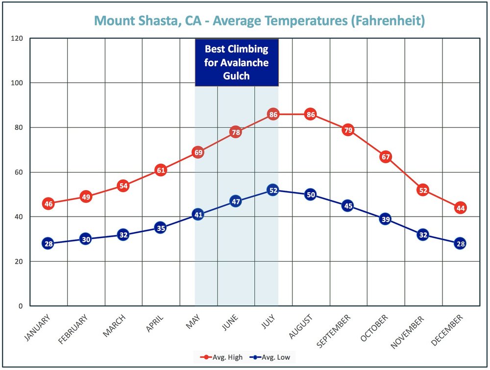
Most people attempt the Avalanche Gulch route on Mount Shasta between mid-May and mid-July. This is the best time to do this route because you typically get optimal weather conditions and snow pack coverage during this time of year.
If you wait until too late in the summer, the snow melts and there is a lot of loose scree, which causes the hike to be more challenging – and also more dangerous because there is a higher chance of rock fall in the Gulch.
Whenever you visit Mt. Shasta, always be prepared for rapid weather changes. Mount Shasta can jump from perfect conditions to stormy conditions at any time of the year, and sometimes it can happen in the span of only a few hours. Also anticipate for winds to be greater the higher you ascend the mountain.
This means you should also come prepared with extra rain gear and layers when climbing Mt. Shasta!
Check out the Mount Shasta weather average temperature map below for reference.
Be prepared before you go. Just like I teach my students in my backpacking program. It’s important that you research the weather conditions before you go, weeks and days before your trip. You can check the weather conditions at one of the following resources:
Mount Shasta Avalanche Center Forecast – Maintained by local Mount Shasta Wilderness Rangers
Mountain Forecast – One of my favorite sources for mountain weather forecasts when checking a few days before a trip
Winter at Mount Shasta: The winter months at Mount Shasta are known for high winds, stormy weather, and deep snow. Only the most experienced mountaineers should ever attempt a winter ascent of Mt. Shasta.
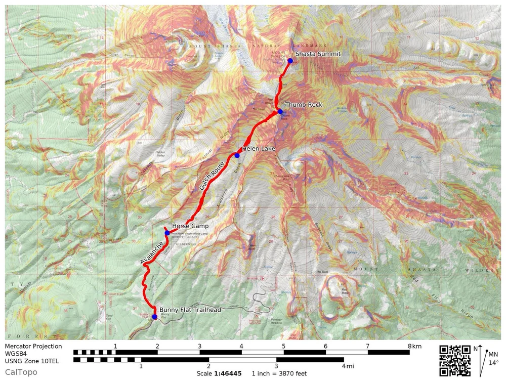
4. MT. SHASTA AVALANCHE GULCH TRAIL MAP & GPX FILES
Here are a couple of different ways to visualize the Avalanche Gulch Route on Mount Shasta.
First is a map I made from CalTOPO which shows a shaded relief map, the Avalanche Gulch trail (in red), and a few of the key “trail markers” along the path up to the summit.
And for an even more “real” look at the Avalanche Gulch route
